
 Check Availability & Booking


The Mull of Galloway Trail
Scotland’s Greatest Trail in South West Scotland
Introduction
The Mull of Galloway Trail is a new 24 mile walking trail in South West Scotland – from Stranraer to the Mull of Galloway. The trail opened in August 2012 was made possible by the Rotary Club of Stranraer.
The Mull of Galloway Trail can be combined with the Loch Ryan Trail. This trail also starts in Stranraer and heads northwards along the shores of Lochryan into Glenapp where it meets the Ayrshire Coastal Path – so the sky`s the limit!
Most of the trail follows the magnificent coastline of the Rhins of Galloway. The scenery becomes ever more spectacular the nearer you get to the Mull of Galloway.
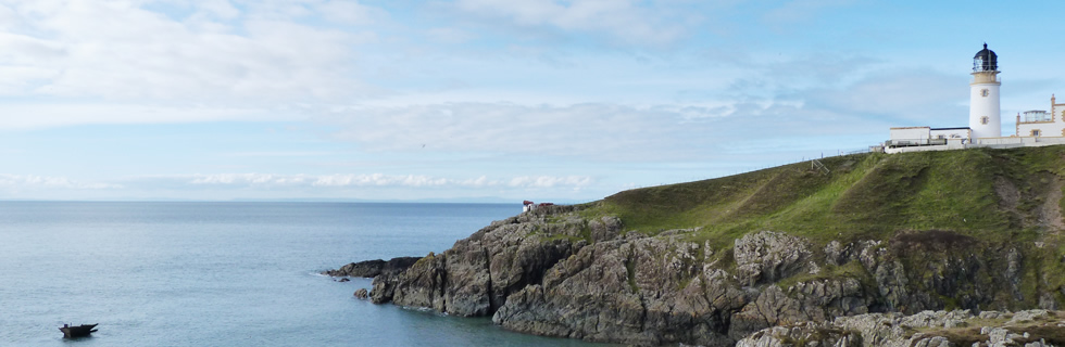
The Mull of Galloway itself is Scotland`s most southerly point – Scotland`s Lands End! Unlike Land`s End in England, our Land`s End is much quieter and has free parking! The Lighthouse is open to the public at weekends and on Mondays during the summer when you can climb the tower and get an even better view taking in four countries- Scotland, England, Isle of Man and Ireland!
Most walkers will chose to complete the trail over two days. Ardwell is approximately the mid point of the trail and there is a bus service every two hours or so between Stranraer and Drummore via Ardwell. Local taxi firms are relatively inexpensive. If you are staying with us at Rickwood House in Portpatrick, we will try to assist with transport arrangements. You can relax afterwards in our new hot tub. Ideal after a long walk!

Looking back towards Maryport from the Trail

New England Bay on the Mull of Galloway Trail
A refreshment opportunity – Gallie Craig!
Stranraer to Ardwell
The Mull of Galloway Trail starts at the Visit Scotland Information Centre in Stranraer and follows the A77 eastward before turning into Ladies Walk. Cross A75 into Westwood Avenue. Turn right through a gap between two houses and onto a track through a wood for about 2k. Cross a public road after 0.5k
On leaving the wood (waymarker #9 – 3k) turn right onto a narrow road. Turn left to cross a field towards a wood. Cross a small sleeper bridge. Go through kissing gates at the entry and exit from a wood. The trail follows a fence with several stiles (to cross to adjoining field if bulls around!)
Continue on the farm access road past High Barnultoch Farm. across a public road (waymark # 8- 5k). Head southwards on quiet roads past various farms to reach the B7084 (waymark #7 – 10k) where the route enters Clayshant Quarry. Continue to the coast. Go right and follow shoreline. Cross Culmore Burn and continue over sand dunes passing the Sands of Luce Holiday Park to cross Sandmill burn bridge. Continue to Sandhead Village (waymarker #6 – 14k)

The beach at Sandhead – miles of sand.
There is a store, hotel and tearoom in Sandhead.
Through Sandhead, if the tide permits, continue on the shore crossing Cairnwell Burn Bridge then briefly on the main road to pass behind Dye Mill Cottage.
If the tide is high, it may be necessary to revert to the road for part of this section.
At Ardwell (waymarker # 5 – 19k) you are about half way to the Mull of Galloway.
The Mull of Galloway
Ardwell to Mull of Galloway
From Ardwell, follow the main road briefly before passing through a carpark/ picnic area.
Approach Chapel Rossan House, cross the main road at the entrance to Barhill Farm and continue along the field edge to cross back over the road into a small wood. Head right through the wood and enter a field emerging onto the access road to Longrigg House and cottage.
Turn left and follow the access road to a waymarker on the right verge then turn right into Longrigg Plantation. Drop steeply, turn right through a wood then left to the shoreline.
Cross Logan Mill Bridge (waymarker #4 – 22k) and continue on shoreline and through New England Caravan Park then cross Terally Burn by the road bridge and cross A716 at entrance to Kirkbride Farm (waymarker #3 – 26k)
Pass through a kissing gate and turn left through Grennan Plantation to reach a kissing gate and access road. Left again and follow access road to main road and cross it following the seaward verge to outskirts of Drummore. Veer left down to the harbour (waymark#2 30k)
There is a shop, tearoom, hotel etc in Drummore
Continue round the harbour to Caliness Road and follow the shoreline to Maryport (waymarker#1 – 33k)
From Maryport Caravan Park follow the coastline before climbing to the top of the slope and follow the seaward side of the fence before dropping back down to the coastline to cross the Kik Burn on a small sleeper bridge.
Continue round the coastline then climb to a drystane dyke which is crossed by a stepladder then continue southwards.

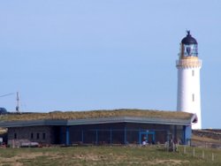
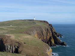
East Tarbet Bay with Mull of Galloway Lighthouse
At East Tarbet Bay drop down and climb back up to the seaward side of a fence and continue along the top of a slope to reach a wall. Pass through a gate and climb up to Mull of Galloway Car Park and trail end (38.6k – 24 miles)
It is hoped to form a further trail along the west coast of the Rhins to link the Mull of Galloway with Portpatrick. This will result in an even better circular route when the first section of the Southern Upland Way from Portpatrick to Stranraer is included.
Meantime, it is possible to walk parts of the west coast. Portpatrick to Knockinaam via Dunskey Castle, around Ardwell Bay, Port Logan and the North/West coast of the Mull of Galloway itself all have great walking opportunities.