
 Check Availability & Booking


Walking in Dumfries & Galloway
- Walks on the Mull of Galloway
- Taxing Stane and WWII Gun Emplacements
- Coastal walk – Stairhaven to Auchenmalg
- Loch Trool Walks (opposite)
- Inshanks Fell & Kirkmaiden
- Climb the Merrick (opposite)
Walks on the Mull of Galloway
20 minutes – 3 hours or more
From Portpatrick turn right onto B7042 about 2 miles from the village and follow signs for Sandhead. Just as you reach Sandhead turn right onto the main road, follow signs for Mull of Galloway and park at the visitor centre (Gallie Craig)
The Mull of Galloway is the most southerly point on the Scottish mainland and is a spectacular viewpoint taking in the fells of Cumbria, the Isle of Man, Ireland including the Mountains of Mourne, Luce Bay, the Galloway Hills. Even the Mull of Kintyre, Arran and sometimes, Jura! There is an interesting exhibition at the lighthouse, a coffee house perched on the clifftop where the views can be enjoyed over some refreshments and an RSPB reserve where amongst others, fulmars, black guillemots, shags and up to 2,000 pairs of gannets nest on the nearby Scar Rocks. Porpoises and grey seals are often seen.
Short walk round reserve
From the car park go through the gate where there is a network of paths taking in the RSPB centre and the lighthouse itself. No difficulties other than the steep steps down to the foghorn where care is required. The path to the foghorn give a good view of the whirlpools caused by the meeting of the 7 tides.
Mull of Galloway – short circuit (about 1.5 hours)
Park at the Gallie Craig Visitor Centre, walk round the front of the coffee house and go through the gate at the end of the building onto a path heading north between the fence and the cliff top. The eroded cliffs around here provide fantastic scenery and there are numerous seabirds to watch.
You will see a monument in the field above you. This is known as Kennedy`s Cairn and if you have a good head for heights it is possible to climb to the top on stone steps. Although I am a keen hill-walker, I passed on the steps!
Returning to the path, follow it until it rejoins the road at a cattle grid. Cross the road and make your way down towards the ruined walled cottage and jetty at the far end of the bay. Pick up a faint path which runs just above the rocks and follow it as far as you dare! (the path is very narrow and quite exposed) It is possible at various stages to scramble up the steep grassy slope where an easier path runs alongside the fence. Follow the fence until the visitor centre comes into view and make your way back to the car park. If the path southward doesn’t appeal, just walk back alongside the road.
Mull of Galloway – long circuit (about 3 hours)
Start off as described above short circuit but before crossing the cattle grid take the path, through the gate on the left (signed footpath to Cairngaan).
After about 5 minutes, descend into a grassy inlet and bear right near the bottom where a faint path leads to the shore. Pick up the path to the right along the sea shore. Go upwards again through a gate and follow the path round the next headland then ascend a somewhat boggy slope until the fence and path is regained.
Walk between the field edge and the fence until you see a post in the field to your right. From the post you will see a lane heading inland. Follow the lane and at a junction go straight ahead, keeping the farm house on your left until you come to a road beside some houses where you turn right.
After 10-15 minutes, a footpath leads off to the right (before the houses). Follow the path round the edge of the field and into an attractive, recently planted wooded valley.
Eventually you come to a fork in the path where you go straight ahead, ie. not upwards to the right. Go through a gate and follow the path to the left and soon reach the road.
The walk can be cut short at this point by turning right along the road and follow it back to the car park.
However, you can, instead cross the road and follow the signed footpath towards the shore. From there, ascend to a field above the cliffs where you can follow the fence until you come to a stile over the wall where you can pick up a good path between the wall and cliff top back to the cattle grid described in the short loop walk described above.
Drummore to Maryport
This is an easy and level walk along the shoreline with a good path and excellent views of the Mull of Galloway
Park at the picnic area in Cailiness Road at the southern end of the village of Drummore. Walk along the road for a short distance until it turns inland and go through a new gate into a small field then out another gate at the far end where a footpath runs just above the shore line.
After rounding Cailness Point, the Mull of Galloway with its lighthouse comes into view and the path continues until Maryport is reached. There are some sandy beaches along the way and Maryport itself where there is a caravan park has a lovely beach.
The walk takes about 30-40 minutes one way.
The return to Drummore can be either by retracing your steps or by cutting through the caravan park and following the roads back although this is a longer option.
The walk can be extended by continuing along the shore (no path) for about 30 minutes until rocks force an ascent of some steep and rough ground to reach the fields above. From here it is possible to reach the road but care is required as a fence needs to be crossed which may be electric! (it was switched off when I crossed) A further footpath starts not long after the road is reached from where it is possible to walk to the Mull of Galloway but a full day would be required for this.
From Cairnryan to the Taxing Stane and WWII Gun Emplacements
Park in the picnic area on the far side of Cairnryan, just past the lighthouse. Cross the road at the far end of the picnic area and ascend steeply up the rd. signed “Little Laight” (etc) this was once the stagecoach route to Ballantrae and the first section must have been very tiring for the horses!
After passing a wooded area, the gradient levels off and there are good views towards the south rhins over Loch Ryan.
Carry on, through a gate until you reach the “Taxing Stane” and you see the remains of gun emplacements on your right. It is possible for the more agile to climb to the top of one of the emplacements utilising an adjacent fence.
This is an excellent viewpoint from where the entire Rhins of Galloway Peninsula as far as the Mull of Galloway can be seen and it gives an excellent perspective of the peninsula. From the viewpoint you can also see over the peninsula to Ireland and north-west to Kintryre.
The Taxing Stane is thought to commemorate the burial of Alpin, king of the Scots of Dalriada, who was murdered in Glenapp in AD741. It was also a boundary marker between the old kingdoms of Galloway and Carrick and is close to the current boundary between Wigtownshire & Ayrshire.
The gun emplacements were for anti-aircraft guns and were one of four emplacements used to defend Loch Ryan during the 2nd World War.
This walk forms part of the Loch Ryan Coastal Path from Stranraer to Glen App where it merges with the Ayrshire Coastal Path and leads north as far as Skelmorlie. If transport can be arranged, it is well worth continuing beyond the Taxing Stane to Glen App church where the path rejoins the main road.
The return walk takes about 1 hour & 10 minutes (the descent is much faster!!).
Coast to Coast in 90 minutes!
Unlike the 212 mile Southern Upland Way, this mini coast to coast walk can be done – there and back in well under two hours!
The walk is from New England Bay on the coast of Luce Bay to Port Logan on the Irish Sea Coast of the Rhins of Galloway.
Start at the picnic area at the entrance to New England Bay Caravan Park – about two miles south of Ardwell. Follow a short grassy track from the car park to the main road. The track is diaganonally opposite and to the right of the car park access road.
Cross the main road onto a narrow public road which is followed all the way to Port Logan where the route turns left and the first left again immediately before the Port Logan Inn to climb back uphill.
After 600m turn left onto a narrow public road and continues past Killumpha Farm and Bridge Cottages at an acute bend.
Back at the main road,cross ove and turn leftr to join the Mull of Galloway Trail along the foreshore back to New England Bay. (7km).
Whithorn to Burrow Head Walk
This is a fairly level coastal walk on a grassy path mainly though farmland. Return either same way or by the minor road. Total distance about 5-6 miles. The walk can be extended from Burrow Head to St Ninian`s Cave.
The path starts opposite the Quens Arms Hotel in Isle of Whithorn. The route follows the coastline on grassy fields and is well waymarked. The scenery gets dramatic as the walk starts to climb to higher cliffs. I spotted a heron while gannetts and cormorants are often seen as well as passing marine mammals.
The path keeps to the seaward side of the fields so take care if its windy! The collumns of the cliffs get ever more imoressive.
Eventually you reach a cairn which marks the highest point. This is where “The Wicker Man” was burned in the cult movie.
Keep following the path to reach the caravan park from which either retrace your steps to Isle of Whithorn, go through the caravan park to pick up the road back or continue on the coastal path to St Ninian`s Cave.
Loch Trool Walks
Two walks at Loch Trool – the first is a relatively easy one along the 7 Stanes mountain bike trail to Loch Dee. The second is a bit more challenging and goes all the way round Loch Trool.
Both walks start from the same car park as the Merrick and it is worth taking a small detour to see Bruce’s Stone from which there is a good view of the loch.
The stone commemorates the Battle of Glentrool in 1307 when Robert the Bruce with an army of 300 Scots defeated an English Army of 1500 men by rolling boulders down the hill then using archers to complete the victory.
There is a beautifully situated Visitor Centre a couple of miles before the car park which is open 10.30am to 16.30pm and provides maps and leaflets etc plus teas, coffee etc along with home baking.
The Visitor Centre has a lovely picnic area beside a waterfall and bridge and provides and excellent place to relax and soak in the scenery either before or after your walk.
Loch Trool to Loch Dee
From the car park at the start of the Merrick climb, follow the 7 Stanes sign along a forest road which takes you through an attractive wooded area, somewhat unusually,oak instead of the normal conifer. The route is well signposted and descends quite steeply at first but then climbs gradually after that most of the rest of the way which makes for an easy return walk.
The trail follows the valley of the Glenhead Burn deep into the Galloway Forest Park, often echoing with the call of cuckoos and provides great views of nearby hills with unusual names such as Mulldonoch, Lamachan Hill and Rigg of the Jarkness.
Around the highest point of the trail, look out on your left for one of the “7 Stanes” a 1.5 ton sculpture resembling a neolithic axe head complete with runic text. From here there are lovely views of Loch Dee with it`s sandy shores.
Follow the trail for as long as you want but remember you need to go back the same way. It is possible to access the loch at several points
Loch Dee is the source of the River Dee which flows through Clatteringshaws Loch and Loch Ken before entering the Solway Firth near Kirkcudbright.
To return to the carpark, retrace your steps and enjoy the glimpse of Loch Tool as you descend the trail. The return walk to the west end of Loch Dee takes about 2 hours 30 minutes.
Round Loch Trool
From the car park set off to the right along a tarmac track used as a cycle path. The path crosses an old bridge across the Buchan Burn, after which fork left (signposted Gairland Burn) and cross the wooden bridge over Gairland burn.
After about 0.5km a footpath branches right leading to a further sign post where you turn rt. and cross another wooden footbridge from where you go straight on uphill on the Southern Upland Way.
Follow the path swinging right and traverse the steep hillside and pass a plaque commemorating the Battle of Glen Trool. After about 2km the path enters a meadow where you turn left onto a cinder track and cross a concrete bridge.
At the next junction turn right and rt. again after about 100m to cross two bridges bringing you to a small carpark where the former Caldons Camp site was.
From here the signposted Loch Trool Forest Trail goes through a cleared area before entering the trees. About 50m after the trees start the trail bears left and a small path ascends gradually away from the loch to the road where you turn right back to the car park.
Time – about 2 1/2 hours.
Climb the Merrick
The Merrick is the highest point in the Southern Uplands of Scotland and is a Corbett. This mountain is 843 metres above sea level and appropriate precautions should be taken as the weather can change rapidly and it can often be extremely cold and exposed at and near the summit.
For regular visitors to the Lake District, the Merrick is only two metres lower than the mighty Blencathra!
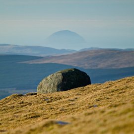
Ailsa Craig from The Merrick – photo by Leeming & Paterson
From Portpatrick follow the A77 to Lochans, turn right in the village and rt. again at the junction. Take 2nd on the left signposted A75 then turn rt. when the road meets the A75. Just before Newton Stewart take a turning to the left and follow the signs for Glentrool.
Access to the Merrick is from the carpark at the end of the public road in Glen Trool. A well used, signposted path leads up beside the Buchan Burn to Culsharg bothy. From the bothy, the path takes you upwards through a forest then through open hillside to the summit of Benyellary. (719m) The path then follows a wall and continues to a col. When the slope broadens out, leave the wall and ascend the grassy hillside by the path which takes you to the summit.
As this is the highest land between the Lake District and Ben Lomond, north of Glasgow, views on a clear day are spectacular and include Ailsa Craig and the west coast as well as the mountains of Cumbria and the Mull of Galloway. It is also nearly always very cold on this section of the walk as this will be the highest ridge in the South of Scotland.
It is possible to vary this walk by ascending via a series of lochs and it is suggested that OS sheet 77 is studied in detail beforehand.
Unless you are used to regular hillwalking, approximately 5 -6 hours return should be allowed for the walk by the main path. The car journey is just under an hour each way.
Coastal walk – Stairhaven to Auchenmalg
This walk follows a signposted and waymarked footpath and provides excellent views of the Mull of Galloway, Burrow Head and the Isle of Man. There are opportunities to explore the shore-line and view birds including cormorants and the chance of seeing a seal or two
From Portpatrick, take the A77 to Lochans, turn right in the village and right again then follow signs for A75. Shortly after joining A75 turn right for Stairhaven and park in the picnic area.
The footpath starts just to the left of Fisherman`s Cottage and climbs fairly steeply for a few minutes before levelling off and running along above the shore line. Good views of the Mull of Galloway. After a while, the path reaches a field and becomes indistinct. Follow the seaward edge of the field and at the far end of the field and, slightly inland, the footpath becomes obvious again where the track crosses a small stream.
Soon the view changes to the Isle of Man and Burrow Head where Edward Woodward met a grizzly end in the cult Wickerman movie. The path continues over stiles but is always obvious until it descends to join a farm road near Auchenmalg. This is the end of the walk, however it is only a short distance to the Cock Inn at Auchenmalg which has a tea room open 10am – 3pm daily except Mondays. To reach the Cock Inn, it seems to be ok to skirt round the back of a recently built wooden house as walking the shore at that point would involve crossing a stream. You may prefer to go up the farm road to join the main rd. from which it is only a short distance to the Cock Inn
Stairhaven was a port for a brief period around 1826-1850 but trade gradually declined thereafter. The remains of the harbour can still be seen. Now there are just a few houses but it is a pretty spot to have a picnic or to explore the beach.
From Auchenmalg, the best plan is to retrace your steps back to the car as returning by road is quite a bit longer
Approx distance: two miles each way.
Time: about 2.5 – 3 hours
Please not that due to livestock, no dogs allowed on the path.
Inshanks Fell & Kirkmaiden
Inshanks Fell may be only 164 metres above sea level but it is the highest point on the South Rhins of Galloway and the view is senstional.
There is no path to the summit, the ground is rough and a barbed wire fence needs to be negotiated so a bit of caution is required but well worth the effort.
Park in the tiny village of Kirkmaiden which is near Drummore. There is usually space to park near Kirkmaiden Old Kirk (which was a location in 2000 Acres of Sky)
Take the turning just south of the Old Kirk beside a red phone box and walk along the narrow minor road to the west. The road is mostly downhill and views are good as you approach Castle Clanyard. Remains of the castle on your right.
Take a left turning at Castle Clanyard farm and walk along a concrete road, past farm buildings bearing left. A burn runs alongside this good track on your left. The track runs uphill away from the farm and after a while, passes a new build house with an interesting round turret, the track turns to grass as has great views.
On reaching the road, turn left and soon you will see a gate on your right. Climb the gate and follow a faint track for a short while then proceed left towards the summit of Inshanks Fell. There is no path but once you reach higher ground, you will see the trig point in the distance. Pick the easiest way through the uneven and, in some places, overgrown ground towrads the summit. There is a barbed wire fence which is too rickety to climb bit an agile walker can crawl below the wire. The fence was broken in places so another option is to find a place where you can step over it.
Once at the summit you will be amazed at the views in all directions taking in the Galloway Hills, Cumbrian Fells, Mountains of Mourne, Isle of Man and much more.
Best option is to retrace your steps back to the road, climb the gate agan and go right towards Kirkmaiden, turning left shortly before the village.
The walk including the fell should take no more than two hours and the ascent of the hill is only about 40-50 metres. It still a great walk even without the hill ascent and would reduce the time to just over an hour.